From Aerospace Testing International By Dave Hughes
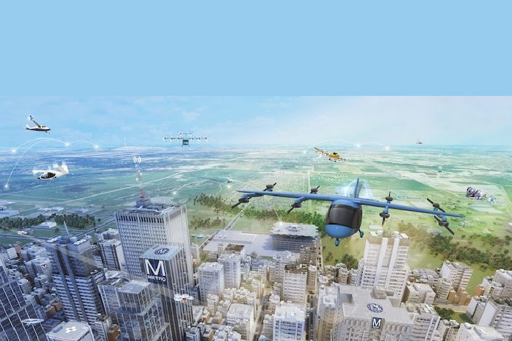
A diverse set of robust facilities and capabilities that are likely to make major contributions to drone, eVTOL aircraft development, refinement of concepts of operations and airspace allocation over the next decade are based in the Hampton Roads, Virginia area on the east coast of the USA. The area hosts an eclectic mix of independent entities often working in partnership.
Research agencies and companies in the region include NASA’s Langley Research Center, the Longbow Group and Raytheon, all of which are working to prove how civil eVTOL aircraft and autonomous drones can operate safely in complex airspace.
NASA’s Langley Research Center in Hampton does more drone flight testing than the rest of the research agency combined. The Longbow Group is an aviation consultancy which has set up a UAS (unmanned aerial system) R&D Technology Centre (USRTC) at nearby Fort Monroe. The city of Hampton also funds a technology business accelerator called Reaktor for UAS startups that works with local universities in the non-profit National Institute of Aerospace, which is based at Hampton Roads.
The area is also home to a growing number of UAS businesses including the Advanced Aircraft Company, Daniel H. Wagner Associates, DroneUp and Hush Aerospace. DroneUp was founded at Virginia Beach in 2016 and last year started working with retailer Walmart to provide commercial drone delivery operations.
Longbow plans to deploy UAS traffic management (UTM) over downtown Hampton and develop autonomous Beyond Visual Line of Sight (BVLOS) routes for first responders and regional air logistics over the Southern Chesapeake Bay, the largest estuary in the USA. The company plans to one day fly unmanned drones to the Eastern Shore of Virginia to Cape Charles, around 25 miles (40km) away from Hampton and to NASA’s Wallops Island rocket launch facility. The state of Virginia has also built a US$6 million UAS runway at Wallops for US Government and commercial users to discretely test UAS at a secure federal facility. The runway is below 75 square nautical miles of restricted airspace available for flight testing 24/7.
Radar research
The US military has a large presence in the Hampton Roads area. Naval Station Norfolk is home of the US Navy’s Atlantic Fleet. The area also hosts Langley Air Force Base which is home of the USAF Air Combat Command, as well as the Army’s Fort Eustis and Felker Army Airfield where combat, training and transport helicopters operate.
Raytheon has donated a Skyler X-band, dual-polarized, phased array radar to Hampton University so it can use the equipment to collaborate with NASA Langley, the City of Hampton, and Longbow in NASA Langley’s Advanced Air Mobility (AAM) High Density Vertiplex (HDV) Project. The radar sits atop the University’ Harbor Center in downtown Hampton, at 200ft high the tallest building on the peninsula.
Longbow, along with NASA Langley and Hampton University, can now monitor flights of drones and air traffic out to 15 miles (25km) with the Skyler radar. At the same time researchers from the University’s Center of Atmospheric Sciences and its Aviation Department work with NASA examining weather conditions below 400ft out to 18 miles (30km). Longbow is exploring ways to commercialize the radar. The company also has a waiver from the FAA to fly drones in the airspace in the area. It plans to evaluate regional logistics cargo operations. FAA permission to fly BVLOS revenue flights will initially be easier to secure over water than over land.
Also in the area, Newport News-based Huntington Ingalls Industries (HII), is creating a military Unmanned Systems Centre of Excellence in Hampton that will employ 250 people. HII is the largest Naval shipbuilder in the USA and builds US Navy aircraft carriers. At the new unmanned systems centre, HII is assembling hull structures for Boeing’s Orca Extra Large Unmanned Undersea Vehicle program for the US Navy. Testing conducted off nearby Virginia Beach in 2021 by HII showed how drones can communicate with unmanned Naval vessels and communicate with unmanned surface ships to change their speed and heading.
Urban Testing
NASA Langley opened a 100 acre drone test range over marshland on its campus in 2015 called CERTAIN (City Environment for Range Testing of Autonomous Integrated Navigation). Researchers use it to fly small, unmanned drones as surrogates for larger UAM aircraft. There are multiple radar systems for surveillance and in a control room in the NASA laboratory researchers simulate autonomous drone flights before flight testing them. NASA scientists will soon be flying unmanned drones over the buildings at the research center on weekends as NASA gains FAA permission to fly over people. Almost everything they are doing is subject to technical transfer to industry.
“The point in the UAM ecosystem where people will actually be able to make money is where the average person can afford to use it,” said Lou Glaab, assistant branch head for the aeronautic systems engineering branch at NASA Langley. “To achieve that you are talking high density with lots of traffic and lots of aircraft. I’m sure some companies could fly eVTOLs in place of helicopters, but that’s only going to serve a very small percentage of the population.
“We are doing rapid prototyping and assessment on the integration of the different elements involved with onboard automation and automated airspace to have a vertical automation system.”
A NASA project called Pathfinder aims to take separate UTM research projects and combine them into a single autonomous vehicle to fly and communicate with other autonomous air vehicles in the airspace. “Pathfinder was conceived as a way to perform a graduation exercise for a lot of the UTM projects we developed over the years,” Glaab said. “We’re testing things like Icarus, an autonomous sense and avoid flight management system for unmanned systems. There is also Safe-2-Ditch, an autonomous safe landing or crash management system.”
If a drone, simulating an eVTOL, has to make an emergency landing, Safe-2-Ditch identifies a suitable landing site where there is no activity. The tests also use geo-fencing to avoid buildings and power lines or the flight of another air vehicle. NASA Langley’s Air Traffic Operations Laboratory is also monitoring flights and making control decisions for active air vehicles. Researchers study human factors including how operators observe surrounding traffic to obtain data on the level of difficulty in managing urban traffic.
Glaab is also the technical lead on the High Density Vertiplex sub project (HDV). This focuses on examining how multiple vertiports would operate if located in close proximity to one another in an urban area. It addresses scalable and efficient aircraft operations, flight and airspace management procedures and vertiport operations in a high-density vertiplex environment. Small UAS will fly as UAM aircraft surrogates to a vertiport at NASA Langley and two which are to be built by Longbow for UAS and eVTOLs at Hampton.
The creation of a representative UAM system aims to mitigate risk for future R&D. Langley’s airspace operators laboratory and autonomous vehicle applications laboratory will serve as a base of operations for airspace systems integration of systems and software from UTM to support HDV concepts. Airspace management automation technology will be evaluated along with human factors.
Flights using the BVLOS flight corridors being developed by Longbow and NASA Langley over Chesapeake Bay will begin in 2023. The aim is to enable maritime surveillance operations with small UAS with the participation of Hampton University, the city of Hampton and Raytheon. Longbow is also a partner on the HDV project and the corridors will take advantage of the technology it is developing. Longbow aims to develop maritime search and rescue capability for Hampton and the city’s police force to use, which will cover of hundreds of square miles in the lower Chesapeake Bay.
Marco Sterk, CEO of the Longbow Group founded the company in 2006. Sterk has more than
30 years of experience in aviation. He started his career at Fokker in 1988 flight testing the F100 in Spain, before joining Airbus and then becoming the chief development engineer for FedEx in 1997. Sterk also started a UAS services company, 901Drones, to provide commercial UAS services in Memphis, USA which is still operating today and working with FedEx to develop its UAS.
Longbow’s long term goal is to develop an autonomous ecosystem of UAS by 2028 that works commercially and is scalable. “If we can solve it here in Hampton Roads, we can solve it anywhere,” Sterk says.
Longbow plans to produce data from its research efforts to help the FAA and NASA develop UAS. It also plans to develop a new commercial air service called Pegasus UTM.
“We are not a drone testing site,” says Sterk. “For our airspace research we use proven, reliable drone systems, flown by us or our clients or partners. We have a license agreement with the City of Hampton and the Fort Monroe Authority to operate our USRTC at Fort Monroe.”
Longbow has a mission operations control room set up at the Hampton police station and plans to renovate a 11,000 square foot building to operate USRTC. Longbow trains local students from Hampton University and Virginia Peninsula Community College including military veterans to fly drones under Part 107 for its programs. “Direct hands-on student involvement in all our research programs and workforce development is very important to me,” says Sterk, who also teaches a drone design and building class at the Virginia Peninsula Community College in Hampton.
AI integration
Another project Longbow is working on is MORPHEUS (Multi-Objective Risk Prediction and Hazard Evaluation / optimization for Urban Air Service). This NASA-funded project is applying artificial intelligence and machine learning to predict urban population densities over time based on historical data and other inputs to select safer UAS and eVTOL aircraft routes over populated areas. “We plan to use MORPHEUS as part of our safety case with the FAA. We will use it to apply for authorizations to fly autonomous operations over the populated areas of the city as part of an enhanced Drone as First Responder project,” says Sterk.
“In the past four years we have demonstrated with USRTC that Hampton Roads is not only a great area for airspace management research, but is also an evolving UAS / UAM market,” says Sterk. “This is a place where the research can be applied and commercialized to serve the 1.8 million people living here and ultimately the 18 million living around the Cheapsake Bay watershed.
“We are already seeing the positive results of attracting new companies to Hampton Roads and we are actively developing the needed workforce and supporting local entrepreneurs.”
The company has also recently submitted a Type-1 proposal for the planning of a new regional National Science Foundation (NSF) funded Innovation Engine called CASMIR (Chesapeake Bay Autonomy and Smart Mobility Infrastructure Research). This project will provide AI-based management of autonomous transportation services in an integrated, multi-domain environment, with a focus on technology R&D and social integration. The team for this grant includes Hampton University and the University of Maryland Eastern Shore, Daniel H. Wagner Associates and The Washington Group.
Flying drones over water, NASA Langley and Longbow are learning how to see and avoid a container ship that is 200ft tall, how to deal with low-altitude coastal weather and salty air’s effects on maintenance. Longbow is partnered with TruWeather Solutions and ResilienX on several NASA-funded research projects focused on Urban Weather Sensing Infrastructure Testbed in Hampton Roads. Companies involved include MetroWeather, Japanese firms supplying Wind Lidars and Pablo Air from South Korea, which is supplying cargo carrying capable eVTOL drones.

